Стопа:NewSwabiaMap.jpg
Айдать на коробушку
Айдать на сыскальник

Size of this preview: 600 × 600 pixels. Other resolutions: 240 × 240 pixels | 480 × 480 pixels | 714 × 714 pixels.
Original file (714 × 714 pixels, file size: 68 KB, MIME type: image/jpeg)
Summary
| Description |
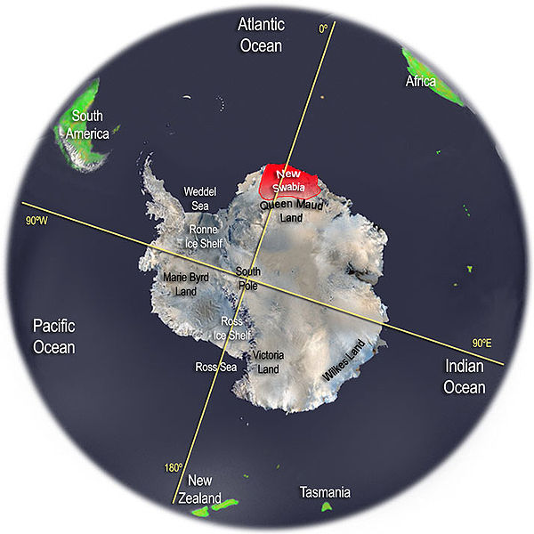
English: Map of the area of Antarctica that Nazi Germany briefly claimed as "New Swabia". Sources:
|
| Date | 29 January 2006 |
| Source | Own work |
| Author | Thomas Blomberg |

|
This map image could be re-created using vector graphics as an SVG file. This has several advantages; see Commons:Media for cleanup for more information. If an SVG form of this image is available, please upload it and afterwards replace this template with
{{vector version available|new image name}}.It is recommended to name the SVG file “NewSwabiaMap.svg”—then the template Vector version available (or Vva) does not need the new image name parameter. |


Licensing
I, the copyright holder of this work, hereby publish it under the following license:
This file is licensed under the Creative Commons Attribution-Share Alike 2.5 Generic license.
- You are free:
- to share – to copy, distribute and transmit the work
- to remix – to adapt the work
- Under the following conditions:
- attribution – You must give appropriate credit, provide a link to the license, and indicate if changes were made. You may do so in any reasonable manner, but not in any way that suggests the licensor endorses you or your use.
- share alike – If you remix, transform, or build upon the material, you must distribute your contributions under the same or compatible license as the original.
File history
Click on a date/time to view the file as it appeared at that time.
| Date/Time | Thumbnail | Dimensions | User | Comment | |
|---|---|---|---|---|---|
| current | 04:00, 29 Сечня 2006 | | 714 × 714 (68 KB) | commonswiki>Thomas Blomberg | Antarctica map with the Nazi Germany claim area New Swabia highlighted. The map is done by me, Thomas Blomberg, in Photoshop, using a variety of sources, including a satellite image (i.e. NASA) of Antarctica.~~~~ |
Вязки
The following page uses this file: